Monday, January 30, 2012

Serenova


The 6,533-acre Serenova Tract is located in western Pasco County, with a single roadside entrance granting access to its 18 miles of trails. It borders Starkey Park to the south, which in turn borders the Anclote River Ranch Tract to its south, and together they form what is known as Starkey Wilderness Preserve.

Serenova’s entrance is on the south side of State Road 52 across from the end of Hayes Road, two traffic lights west of the Suncoast Parkway. From the parking area, hikers and mountain bikers enter through a walk-through opening in the fence while horseback riders enter through a cattle gate. The separate openings result in separate paths at the beginning, but they merge very soon and every mile of trail is open to hikers, bikers, and equestrians alike.


About 1½ miles south of the entrance, the merged trail forks and proceeds to branch out into a series of far-reaching, interconnected loops. A power line travels the length of the preserve on a tight northeast-to-southwest angle, and the break beneath, which is crossed by several of the loops, can be used as an alternate hiking route. The trail map shows the power line and is quite reliable as long as you remain on paths that are signed.

Something I like is that Serenova contains numerous bodies of water despite not seeming all that watery. The Pithlachascotee River bisects it from east to west and several lakes are visible from the trails. Given the length of the trail network, you can walk past the same lake at different times of day and see what it looks like in different light:


Some 150 species of birds have been documented here, coming in all shapes and sizes. On a recent hike I watched a wood stork fly overhead and land in a tree, chasing away a white ibis that had been perched there. A minute later, when I held up my cell phone to snap a picture, the stork took flight and I was lucky to capture him in a full nose dive. It is hard to believe digital photography has come so far that I was able to capture this shot from a phone:


Other creatures in Serenova include scrub jays, gopher tortoises, and rattlesnakes. It may excite you to know that black bears have been documented here, though it is not known whether they are residents or simply pass through on occasion.

And if you are a history buff, it may excite you to know that a decaying chimney deep in the woods has long been rumored to be the remains of a hideout used by Al Capone.

Less than a half-mile into the preserve is a camping area that offers a good option for experiencing it. You can pitch your tent after work on a Friday, then arise before dawn and have time to explore the entire trail network by nightfall, then bed down again on Saturday and be home well before lunch on Sunday.

The camping area is comprised of an equestrian site on the east side of the trail and a non-equestrian site on the west, with a latrine in between. Each site is shaded by live oaks and is so spacious that it looks like it could accommodate a dozen tents with plenty of room to spare. Picnic tables and fire rings (which double as grills) are spread throughout. Serenova is owned by the Southwest Florida Water Management District, and as is the case with practically every campsite on district property, these are immaculate despite not having electricity or running water.

You will be cheating yourself if you fail to check this place out. Happy Trails!


Wednesday, January 18, 2012

O’Leno

O’Leno State Park is 25 miles north of Gainesville, so it might seem strange to include it on this blog, but it would be a disservice if I failed to do so this week. It is one of my favorite places in Florida and we just celebrated my 41st birthday by camping there for the fifth time in seven years:


O’Leno borders River Rise State Park, and for all intents and purposes they are a single preserve whose preeminent feature is the Santa Fe River. While the Santa Fe’s tea-colored water and lazy current make for a classic Florida waterway, it also has a couple features not normally associated with Florida -- a population of beavers and section of rapids. Right now, however, its water level is so low that the rapids are kaput:


The Santa Fe does something unusual by dropping below the earth in O’Leno, then flowing underground before re-emerging in River Rise. Although you can hike to both the sink and the rise from the end of O’Leno’s park road, the only way to really experience the preserve is by staying overnight. This allows you to lie under the stars and listen to the wind in the trees. It also allows you to walk the 13+ miles of trails on your own schedule, rather than having to leave home hours before daybreak just so you can arrive early enough to finish hiking before the gates close.

O’Leno’s most popular route is the River Trail, a 1.4-mile loop that begins at a suspension bridge near road’s end. If you want to walk it clockwise, cross the bridge and turn left, but if you want to go counter-clockwise, turn right before crossing. The trail is marked by yellow blazes and is very easy to follow. Here are Sarah and Erika on the bridge during a prior visit:


Across the bridge, the River Trail’s clockwise course begins by travelling along a bluff over the Sante Fe. This is a good place to keep an eye out for gators and waterfowl in the water below. Eventually it turns away from the river and passes through a transitional zone with pine/palmetto woods on the left and an oak forest on the right.

A few minutes later, an obvious (but unofficial) path on the right leads down into a low-lying area where you will find a spot densely filled with cypress knees. On a visit in 2008, we dubbed this “the field of knees”:


The same day we did the dubbing, Sarah clutched one of the knees and posed for this mock shock photo:


And now, three days ago, she reenacted the scene. I have to admit it chokes me up to see how much she has gown in what seems so scant a period of time:


Anyway, as the River Trail continues to make its way to the river sink, it travels across a rumpled landscape with quite a few ups and downs -- more than enough to keep you interested even though the heights are not soaring. You will also pass a couple of slender lakes, including Ogden Lake, which is pictured below:


These are not oxbow lakes, but as you can see, they have that riverine look that brings oxbow lakes to mind. And there is a good reason for this: They are parts of the Santa Fe’s underground passage that have been exposed by the earth above them collapsing. One clue of this fact is that the lakes all have a slow, but perceptible, current; another is that they are all located at the bottom of depressions.

When you arrive at the sink, don’t expect it to look anything like a river flowing into a cave. Rather, it is a spot where the undercurrent drops slowly and imperceptibly into a hole in the river bed, and it looks like the Santa Fe has simply come to an end. The sink resembles a putting green because of how much algae coats its surface, as you can tell from this picture of my friend Jason standing beside it with his kids, Carson and Lexie, during that 2008 visit I mentioned earlier:


Branching off from the River Trail is Paraner’s Branch, a 3.7-mile trail which heads out onto the “natural bridge” (as the land above the river’s subterranean route is called) and passes several lakes that are the result of sinkholes filling with water. At its southernmost point Paraner’s Branch turns back at a roughly 45-degree angle, and from this apex the Sweetwater Trail stakes off on its own, leading 1.9 miles to a backcountry campsite complete with a fire ring and privy. This is a good destination if you want to try backpacking in the Sunshine State.

Beyond the campsite, the Sweetwater transitions to the River Rise Trail, which travels 4¼ miles to, of course, the place where the river emerges from underground. I have never hiked all the way there, mostly because it’s too long of a dayhike to work into a family camping trip with young kids. I do take no-kids-allowed backpacking trips, however, and one of these days I would like to take one to the rise.

O’Leno has two developed campgrounds accessible by car from the main road. One is called the Dogwood Loop, the other the Magnolia Loop, and I have stayed at both.

The Dogwood is closest to the park entrance and circles through an old, large sinkhole that the forest has reclaimed. This lends actual topography as the road gains a bit of elevation from beginning to end. All the campsites are on the inside of the loop.

Conversely, the Magnolia is level with all its sites on the outside; and it is located near the end of the park road, not far from the parking lot which marks the park’s day use area. There is a playground in the Magnolia, which makes it a better option for families, and don’t let yourself think that a playground automatically detracts from “the natural experience.” When Sarah and I were standing in it on Friday , an owl flew right over our heads, and during a trip in 2009 she found this lizard on the playground and named him “Fun”:


As a father, I prefer the Magnolia because of the playground. As a hiker, I prefer it because it is within walking distance of the trailhead which grants access to all the paths described above. And based simply on my personality, I like that the Magnolia’s sites are, for the most part, more spacious and more private than those on the Dogwood.

But back to hiking. O’Leno has a geologically interesting trail called the Limestone Trail, which departs from the park road roughly halfway between the two campgrounds. It is a 0.6-mile loop that passes a pond and leads to yet another big, old, since-reforested sinkhole (come to think of it, there are so many of these here that it’s amazing the whole park hasn’t caved in!). When you get to the hole, you will find a limestone outcrop hanging over its edge, imparting a feeling of elevation and making it seem like you are standing somewhere further north:


You will also see signs for the Dogwood Trail, which totals almost miles and comes close to connecting the campgrounds. It is not a bad trail, but if you have to choose one to skip, this is the one because it parallels the park road so closely that you could walk its entire distance and feel like you never really went anywhere. (Although, having said that, I did once walk it as night fell, and that did feel adventurous because every darkening tree suddenly looked mysterious and every noise in the brush suddenly sounded scary).

O’Leno is a place you should definitely visit, and I recommend staying a few days so you can mix your active time with your down time. Here is an example of the latter from this past Sunday, taken from my camp chair while Erika read a book in the hammock:


Happy Trails!

Wednesday, January 11, 2012

Cypress Creek Redux


Last week I wrote about Cypress Creek Preserve, and today I feel the need to supplement that post, especially when it comes to the unsigned trail I described as traveling “for a considerbale distance along the spine of what passes for a ridge in Florida.”

After publishing the post, I realized that despite visiting Cypress Creek quite often, it had been a few years since I really bothered to walk that particular trail. And when I mentioned that last winter “Sarah and I ventured down off the ridge and were met by an armadillo,” I didn’t think to mention that we did our venturing less than 100 steps past the point where the trail “enters the shadows of a hardwood canopy, turns south, and narrows”...so of course, I also didn’t think to mention that that was as far as we went that day.

Therefore, I returned to Cypress Creek this weekend to sharpen my memory of the trail, and here I am this evening, seeking to offer some more details about it as well as to clarify some points about the preserve in general.

For one thing, this weekend’s walk reminded me that the trail does not travel a singular ridge, but a dual one. Not very long after turning south, it forks into parallel paths atop parallel ridges with the one on the west notably higher than the one on the east. This picture was taken from the west ridge looking over at the eastern one:


Sarah wanted to cross from one to the other and I told her to go ahead. Here she is in the saddle between them:


Because I previously wrote that the trail travels “a considerable distance,” this weekend I brought my Garmin wristwatch so I could measure it and be more specific. My friend Tom and his son Jackson were with us, and we did not follow the trail to its end due to being somewhat slowed by the kids; however, we had walked a half-mile past the trail’s “turns south” point when we decided to turn around. This was at a spot that is obvious because: 1) the path up ahead starts looking overgrown, and 2) off to the right, a house suddenly comes into view.

If you check out the trail map, you will see a spot where the preserve narrows so much that it is pinched inward by private property. I believe that is the precise spot where we saw the house and turned around. (Remember that this trail does not appear on the map, and, unlike the others I wrote about last week, is not signed.)

Anyway, in my previous post I said that you will not see Cypress Creek itself on the trail network I was writing about. However, now I think I was wrong. This weekend I snapped the following picture at the bottom of the east ridge, and looking at it along with the map I linked to above, I am pretty damn sure this has to be Cypress Creek:


And here is something else worth mentioning -- if you hike this trail soon, you will find that it reveals that much of Florida’s fall foliage lasts all through the winter:


If you hike it with your kids, you may learn a thing or two about perspective. Most adults (including me) would consider an old stubborn vine draped across a trail to be an obstacle, but Sarah and Jackson immediately saw it as a swing to be played on. Jackson seemed to enjoy it even though his extra heft caused him to bottom out:


One last thing I want to point out is this: When I said last week that the trail network totals 12 miles, I was quoting the preserve’s own web site; but when I attributed mileage to specific trails, I was “quoting” my Garmin.

Happy Trails!

Monday, January 2, 2012

Cypress Creek

Cypress Creek itself is one of the Hillsborough River’s major tributaries. Cypress Creek Preserve was established to protect its water quality by setting aside the wetlands that feed it, as well as the higher, drier woods around them:


The preserve encompasses 7,400 acres around the creek’s upper reaches in Pasco County, and ranks as one of my sentimental favorites because it is the first place I went hiking when I decided to start appreciating our area’s wild lands back in 2005. It is within 15 minutes of my home, so I visit quite often and have spent more time there than in any of the other places mentioned on this blog.

The preserve is elongated from north to south, with one trail network branching across its northern portion while another delves through the west-central portion. Today’s post covers the latter, which totals more than 12 miles and is accessed from an entry point on Parkway Boulevard. The trails are unpaved, but the phrase “Jeep roads” would be an accurate description for most of them:


To the delight of hikers, a cattle gate at the entry point keeps cars out. After entering through the fence’s walk-through opening, you will see the primary trail heading due east straight as an arrow. It eventually proves to be a 2.4-mile lollipop loop, and every other trail in the network branches off from it.

Much of the primary trail travels through fields instead of forests, though the forests are so close it feels like you could touch them. If you pay attention you will notice that the fields are home to a surprising variety of plant life in all shapes and sizes:


In the first half-mile you will encounter four junctions with other paths. Two are on the left-hand side, marked by signposts 2 and 5, and will be described later. The others are on the right-hand side, marked by posts 4 and 7, and are actually opposite ends of the same, relatively short side path.

Roughly six-tenths of a mile into the preserve, post 8 is the spot where the primary trail splits to begin its loop. The left fork has the same packed-earth surface on which you have been walking since the beginning, while the right one switches abruptly to a grassy surface. Along the loop you will encounter a three-way intersection, marked by post 10, that can be confusing if you don’t know where you are going -- so be sure to turn right at that intersection if you go clockwise or left if you go counter-clockwise.

The loop provides great birdwatching, as it is where I have seen coveys of quail and flocks of turkeys and some very big red-shouldered hawks. It is also where you will find both campsites: One labeled “primitive” on the inside of the loop, and the other as “equestrian/group” near the end of a signed side trail on the outside. Both are very spacious; both have multiple fire rings; both have sheltered picnic tables; and both have clean port-a-lets that are very well set-aside. These sites are among the best you will find despite not having any electricity or running water. This picture shows part of the one labeled “equestrian/group”:


About halfway through the loop is another obvious side trail on the outside. Although it is unsigned and does not appear on the trail map, there is no way anyone who is adventurous can pass by without exploring it. It goes east a short ways to a tree line, at which point it enters the shadows of a hardwood canopy, turns south, and narrows. Then it travels for a considerable distance along the spine of what passes for a ridge in Florida.

Of all the trailways mentioned in this post, the segment on the ridge -- elevated above terrain that is often wet -- is the only one narrow enough to avoid being called a Jeep road. During a dry spell last winter, Sarah and I ventured down off the ridge and were met by an armadillo:


But about those side trails I mentioned earlier, after entering Cypress Creek you come to the first one almost immediately at post 2. The one at post 5 is about two-tenths of a mile further in and leads to a pond where Sarah and I have clowned around (as you can tell from the next picture). It circles the pond, and a path branching off from the circling portion travels a short ways along a transitional zone between a forest and field.


Meanwhile, the first side trail is a lollipop loop of 4.3 miles, with its fork occurring at the 1.2-mile mark. It appears to be the least used trail in the entire network, which is a shame because I think it is the best:


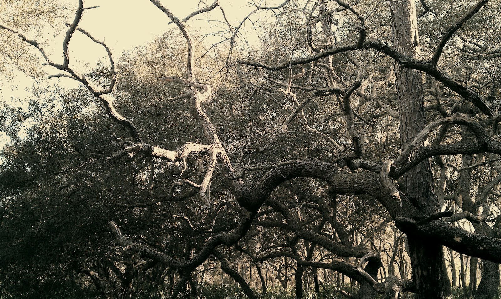
It starts out travelling north, skirting around the edge of a low-lying wetland, then turns and charts more of a northeastward course. It goes through almost every kind of habitat associated with peninsular Florida, from swamps to upland woods to meadows of bluestem, and takes you up close to mysterious-looking cypress and ancient-looking oaks:


Cypress Creek Preserve is a splendid place to see animals. I already mentioned some of the bird species I have viewed here, but those are only the beginning; I have seen so many others that I consider it a grievous error that Cypress Creek was not included on the Great Florida Birding Trail.

Plus, I have seen deer on every one of the trails mentioned in this post. And in addition to the creatures you see face to face, many others leave signs that they dwell here both above and below the earth:


To get here from the north, turn onto Parkway Boulevard from Ehren Cutoff and drive about 1¾ miles. From the south, drive to the end of Collier Parkway and turn right on Parkway Boulevard. Either way the trailhead is on the left.

Do not expect to see Cypress Creek itself on this trail network, however. For that, you will need to check out the one to the north. Happy Trails!